▎Achievements
Re-Connecting the Link between Extreme Geohazards and the Past through Foraminifera
Taiwan’s unique geographical location makes it susceptible to extreme events triggered by climate change and tectonic activities, such as typhoons and earthquakes. By thoroughly examining the comprehensive record of past intense geohazard events, insight can be gained into the frequencies and predictions of these events. Extreme geohazards can lead to submarine landslides in the form of turbidity currents, but although many turbidite layers have been identified in the offshore sedimentary record of Taiwan, knowledge regarding the sediment’s origin, its original water depth, and its triggers remains limited.
To improve our understanding of submarine landslides off the coast of Taiwan, a collaborative research effort was undertaken by NTU’s Institute of Oceanography postdoctoral researcher Raul Tapia, Assistant Professor Sze Ling Ho, Associate Professor Pei-Ling Wang, Associate Professor Chih-Chieh Su, and graduate students Edwin Sicheng Le and Jheng-Kuan Lin. This team of researchers partnered with institutions in Taiwan and France to assess the utility of planktic and benthic foraminifera in identifying submarine landslides and estimating the initial water depth at which the transported material was deposited. An article based on the findings of their study, “Planktic-benthic foraminifera ratio (%P) as a tool for the reconstruction of paleobathymetry and geohazard: A case study from Taiwan,” was recently published in Marine Geology.
The study analyzed 148 sediment samples collected over the past two decades from offshore Taiwan. During research vessel expeditions, the team collected NOR1, OR1, OR2, OR3, and samples obtained from a joint Taiwan-France cruise aboard the R/V Marion Dufresne. Various data, including foraminifera abundance, grain size distribution, total organic carbon (TOC), and carbon-to-nitrogen (C/N) ratios, were generated from the collected sediment samples. These data were then compared to hydrographic data collected and curated by the Ocean Data Bank and GLODAP database.
The results revealed a strong correlation between foraminiferal abundance, planktic-benthic foraminifera ratio (%P), and water depth in the offshore area of Taiwan. The %P value increased as the water depth increased. The team also discovered that by applying this water depth %P equation, sediments influenced by submarine landslides could be identified because they exhibit %P values that differ significantly from sediments found within the same water depth range. Data obtained from Taiwan’s offshore records and other regions were further used to develop a global water depth %P equation. This equation can be applied to sediment records to help reconstruct the paleobathymetry and gain insight into past extreme events triggered by earthquakes or typhoons.
This research offers invaluable knowledge on the connection between submarine landslides, foraminiferal data, and water depth. These findings improve our capacity to predict and understand geohazards more effectively, better preparing the world to cope with future extreme events.
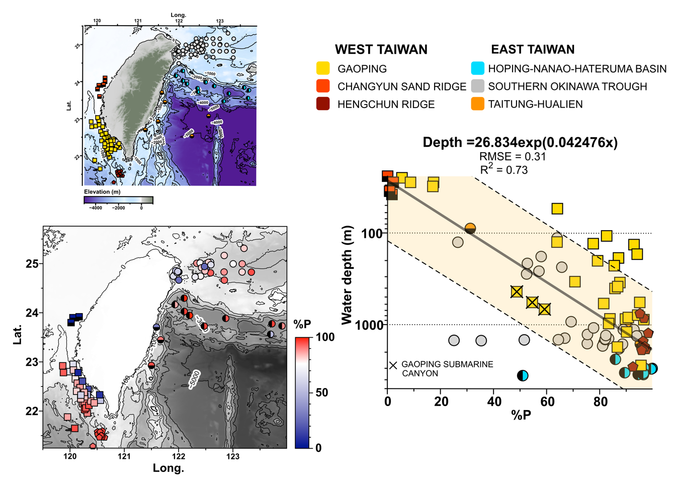
Location of sampling stations and the %P-water depth relationship offshore Taiwan.

Taiwanese and French scientists on board R/V Marion Dufresne during the 2018 EAGER cruise offshore Taiwan.

Click or Scan the QR code
to read the journal article
in Marine Geology.
